Mapping Nature Restoration & Conservation Projects
explorer.land is a unique platform for Nature-Based Projects to:
- Communication through interactive maps
- Monitoring through scientific data & satelite imagery
- Project Funding & connections with investors
Showcase your project
Create your project in a few minutes and easily show its positive impacts on the environnement thanks to:
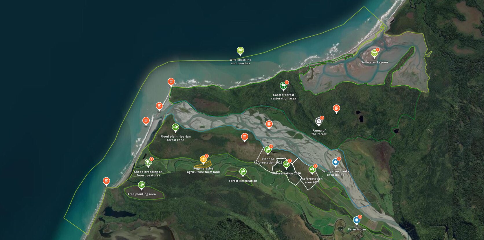
- Satellite images: with Mapbox, Bing, ESRI and NICFI latest images
- Project timeline: to compare satellite images and show the evolution of your project over time.
- Geolocated updates: tell stories directly from the field thanks to geolocated news updates.
- UN Sustainable Development Goals (SDGs): showcase how your project contributes to the United Nations Sustainable Development Goals.
- And much more…
All this for free. In a few clics.
Embed your map on your website
Enrich your communication with a custom map to increase interactivity, trust and engagement.
Bring all your projects to one map
Raise funds
List your project on our funding opportunities to communicate and build trust to connect with potential investors and donators.
Enrich your profile with 3rd-party data.
We're in a crisis of trust... In this day and age you create trust through transparency, not necessarily through social media and colorful marketing materials.

Trusted by +2,000 users around the world

Thanks Alexander Watson, we love using explorer.land maps for storytelling and transparency. It's an excellent tool that gives our clients an opportunity to really dive into our projects 🌲

Since engagement in explorer.land, potential clients, and partners are contacting us. It is a wonderful platform with a super-wide network of potential clients and partners. It has helped us a lot in moving forward with our ecosystem restoration activities. Not only because we can prove exactly what we are doing, but it has also put us in contact with various international clients and partners. The platform really works for us.

An important part of my role at Greenpop is to authentically and transparently communicate the impact of our work to our donors. explorer.land has helped me visually communicate our work. It has combined many of the goals we have for project communications into an easy-to-use platform. The service we have received from the explorer.land team has been exceptional.

OpenForests’ web map has been a fantastic tool to visualize our reforestation project El Silencio for fundraising.

I really love the mobile UI! I know that challenge from Terrastories, and I think you’ve done an excellent job approaching it. I played around with the page and map, and as before, experienced that everything is as intuitive as I expect it to be. Really great stuff!
With the multistakeholder module we could bring all our members and their projects onto one map. In fact, the prospects of using the map-based membership platform is more promising than originally anticipated. We're looking forward to develop the tool together with OpenForests to also meet future, additional demands. The official launch of the map with a video and an article published by Mongabay turned out to resonate very well with our membership as well as outside organisations (e.g., the UN Decade on Ecosystem Restoration) and media.
No! explorer.land has been designed for non-GIS experts. We have put a lot of effort into an intuitive user design. Should you have any additional questions, don't hesitate to contact us.
Projects published and listed on explorer.land increase their visibility and are easily found by funders. Visibility can be increased by using the social sharing function and the call-to-action button to guide the prospects to your fundraising materials.
Furthermore, the map-based project presentation serves as exciting and beautiful communication material, that allows for presenting remote projects in-depth during fundraising events or in one-to-one meetings and video calls.
Yes, project and organization profiles are optimized to be found by search engines.
explorer.land comes with several satellite base maps such as from Bing, Mapbox, and Esri. However, based on your need, additional satellite or drone imagery can be integrated into your project presentation. Please contact us for more information.
Custom features
Contact us and let discuss how we can work together.


