How WeForest uses explorer.land for transparent impact communication

WeForest is a global nonprofit that restores and conserves forests and degraded landscapes — working with local communities to deliver long-term benefits for people, nature and climate.

WeForest use case

Context

As a global leader in Forest Landscape Restoration (FLR), WeForest faced the critical challenge of meeting the rising demand for verifiable, real-time proof of impact from its institutional funders and corporate sponsors.

Traditional monitoring and reporting methods, relying on manual data compilation and static PDF reports, created operational bottlenecks and struggled to bridge the gap between complex geo-spatial data collected in the field and partner management information stored in their Salesforce CRM.

To maintain its commitment to scientific rigor and radical transparency, WeForest needed a scalable digital solution that could seamlessly synchronize partner data with project progress, providing a high-engagement, interactive platform for visualizing their long-term impact on people, nature, and climate.

Mount Mulanje Weforest
Mount Mulanje in Malawi. Credits: WeForest
We're in a crisis of trust... In this day and age you create trust through transparency, not necessarily through social media and colorful marketing materials.
Alexander Watson
CEO & Co-Founder, OpenForests

Key features

explorer.land provides the digital infrastructure required to manage, monitor, and communicate the complex dynamics of large-scale nature-based solutions. WeForest utilizes a large range of features to overcome their challenges. Here are the main ones: 

Public interactive map

The transparency hub for all project data.

Embedding

Seamless integration into the WeForest website.

API Integration

Automated data synchronization with Salesforce.

Sponsor Management

Dedicated visibility for corporate partners.

How WeForest uses explorer.land

explorer.land provides the digital infrastructure required to manage, monitor, and communicate the complex dynamics of large-scale nature-based solutions. WeForest utilizes a large range of features to overcome their challenges. Here are the main ones: 

1. Public Interactive Map

WeForest achieves radical transparency by publicly mapping every project on explorer.land. This move makes all non-sensitive monitoring data immediately accessible to the public, auditors, and potential funders, solidifying trust.

Critically, this strategy transforms communication through interactive storytelling and engagement. Moving beyond the limitations of a traditional PDF report, the explorer.land map empowers users to actively engage with the data—zooming in, selecting different layers (such as tree cover density or satellite timelines), and exploring project complexity.

This dynamic experience significantly improves public understanding of Forest Landscape Restoration (FLR) outcomes.

2. Embedding

WeForest embedded their explorer.land project map on each project page of their website, allowing visitors to explore the projects in an immersive way without ever leaving the WeForest website, and establishing immediate trust.

A visitor reading about the Mahale Mountains project in Tanzania can instantly see the exact boundaries, geo-located field photos, and progress metrics, providing map-based evidence of the work being carried out.

3. API Integration

The cornerstone of this partnership is the custom API connection established between WeForest’s central Salesforce CRM and the explorer.land interface. This integration is critical for solving the data-silo challenge.

The Result:  An automated flow that eliminates the manual effort previously required to create bespoke partner reports. Instead, as soon as funding is logged in Salesforce, the corresponding project’s interactive map on explorer.land is instantly updated with the partner’s name and contribution details.

Value Proposition: This level of operational efficiency saves hundreds of staff hours annually, allowing the Partnerships and Communications teams to focus on engagement and fundraising rather than manual data compilation and reporting.

Workflow: from CRM to geo-data translation

  • Source of Truth: Salesforce remains the master system for all partner and funding data. When a corporate sponsor makes a commitment, the details (funding amount, supported project, duration) are logged in Salesforce.

  • Automated sync: The custom API acts as a secure, two-way bridge. It automatically pulls relevant sponsorship data—such as the name of the funding partner and the specific project sites they support—from Salesforce.

  • Geo-visualization: explorer.land then takes this partner data and automatically links it to the corresponding geo-referenced project polygons, metrics, and media (like photos, news updates, and satellite imagery) that have been uploaded by the field teams.

Data sync between Salesforce and explorer.land
Data sync between Salesforce and explorer.land through API

4. Sponsor Management

Building on the foundation of the API integration, WeForest utilizes explorer.land’s Sponsor Management Module to deliver high-value experiences for its corporate partners.

Sponsor dedicated dashboard: Each major partner receives a link to a dedicated, branded view of the projects they fund. This is not just a static report, but a live, interactive map that showcases their specific impact.

Proof of concept: This dedicated section serves as the definitive proof of concept for the sponsor’s environmental, social, and governance (ESG) or Corporate Social Responsibility (CSR) commitments. They can share this link internally or externally to validate their net-zero or sustainability claims with verifiable, location-based evidence.

Deep Transparency: Partners can delve into details such as:

  • The total number of trees supported by their contribution.
  • The exact project location (e.g., in the Miombo Belt of Zambia).
  • Geo-located news posts and photos showing community engagement and progress over time.
  • Progress against specific Sustainable Development Goals (SDGs) that the project addresses (e.g., SDG 15: Life on Land, and SDG 1: No Poverty).

This feature turns a financial transaction into a compelling, verifiable impact narrative, essential for building long-term trust and securing renewed funding.

The Results

WeForest’s deployment of explorer.land has yielded measurable results across three domains:


A. Enhanced transparency and trust

The public-facing, interactive map has solidified WeForest’s reputation as a best-in-class, highly transparent forest restoration NGO. The move to an open-data communication model directly addresses the “trust deficit” in the climate action sector, attracting new institutional funders and corporate partners who prioritize verifiable impact.


B. Significant operational and cost savings

The Salesforce API integration and the automated Sponsor Management module have drastically reduced the administrative burden on the partnerships team. By eliminating the manual creation of dozens of customized reports per quarter, WeForest has reallocated hundreds of hours of staff time toward core mission activities, enhancing organizational efficiency and lowering reporting costs.

xxxx
Marie-Noëlle Keijzer
CEO & Co-Founder, WeForest
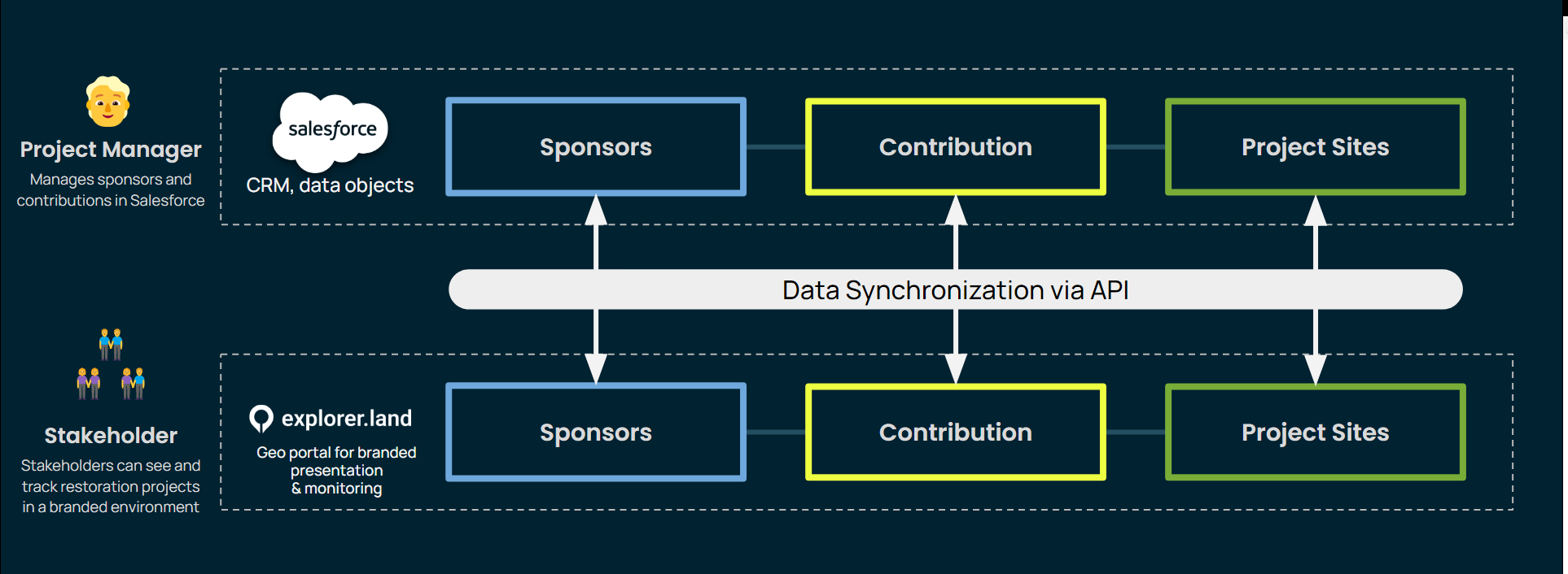
You look at the map and can see the particular polygon that your company have helped restore. That visual sense of the project is really important.
Dave Bircher
Dave Bircher
Ex-Director of Growth, WeForest

C. Scaling partnership engagement

The branded, dedicated partner maps have proven to be a highly effective tool for partner retention and engagement. Corporate sponsors are empowered with a visually stunning, data-driven asset they can use for their own internal and external reporting, transforming WeForest from a project implementer into a co-creator of compelling impact narratives.

Join 900+ organizations